Hiking at and around Falls Brook Yurts
Snowshoes with crampons recommended in winter.The information provided is believed to be true and collected from various sources. Trails change, weather changes, so please follow safe practice for hiking, snowshoeing or backcountry skiing. Read the Safety section of our website for tips.
Sherman Pond – 2.5 miles one way from the yurts- Leave your yurt and head up the main Sherman Pond trail away from the trailhead parking area. This trail is basically a straight shot all the way to Sherman Pond. Follow the state trail markers the entire way.
Stony Pond via Sherman Pond trail - 4.2 miles one way. Follow directions for Sherman Pond and continues on the trail passing along the south side of Sherman Pond. Follow along Big and Little Sherman via the west shore to Stony Pond and a lean-to that sits on its shores at 4.2 miles one way. Bring a lunch for a break at the lean-to.
Stony Pond via Rt28N -2 miles one way. Drive through the Town of Minerva
on Rt28N to trailhead on your right several miles out of town. Gradual uphill to Stony Pond and leanto.
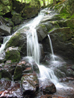
Hoffman Notch Hike – This is a wonderful hike as it does not gain much elevation and follows a brook most of the way. Great kid and dog hike. You choose the distance on this hike. 7.4 miles one way – 8 miles from Falls Brook trailhead parking by car. The best way to see this neglected jewel is to walk this 7.4-mile trail that traverses the tract from south to north, passing through the notch that gives the Wilderness its name. If you do not want to hike the entire trail, hike in half as far as you want to hike and then turn around or spot a 2nd car at the north end of the trail on Blue Ridge Road just south of the high peaks on Blue Ridge Road. A very scenic trail that is wonderful no matter how far you go. From Falls Brook Yurts. Take a left onto O’Niel Road passing the graveyard and old school house on your left. Left onto Irishtown Road which turns into Hoffman Road. Left onto Loch Muller Road to trailhead parking area.Two trails are there—one leading west to Bailey Pond on the left, the other leading north through the notch. The notch trail, marked by yellow disks, descends at once through a mixed woods to cross the West Branch of Trout Brook on a mossy bridge. The land has been part of the state Forest Preserve for nearly a century. About 1.2 miles from the start, you reach the North Branch of Trout Brook. An arrow on a sign points right, in the direction of a trail that crosses the brook and leads to Big Pond. Don’t turn, but continue straight along the west bank. The stream will be your musical companion for much of the way to Big Marsh. Big Marsh is a great place to stop for lunch. The trail hugs the western shore and offers superb vistas of the surrounding peaks with some waterfalls during run off to the left. The highest, Hoffman Mountain, is 3,693 feet. Just beyond Big Marsh lies Hoffman Notch at 1,780 feet. From the southern trailhead, gain only 60 feet in elevation. Hereafter, go down more than up, for the northern terminus is at an elevation of 1,245 feet. Pass through the notch without realizing it, but you will know it when you reached Hoffman Notch Brook, which flows north. The trail follows the brook and crosses it several times. There are no bridges, so the crossings could be tricky in winter. The stream spills over some pretty waterfalls. After the notch, the forest is more open, with smaller trees. You end on private land. The trail crosses Sand Pond Brook on a sturdy bridge and then, as a final treat, passes through a stand of cedars before reaching Blue Ridge Road.
Blue Ledges - 2.4 miles one way
Easy, flat. From Falls Brook, take John Brannon Road from the trailhead parking to the stop sign. Continue straight on Longs Hill Road. Take your next right at Morse Memorial Highway through the Town of Minerva to Northwoods Club Road. Turn left onto Northwoods Club Road and drive another 6 miles on a dirt road to Huntley Pond parking area. (in winter, you may need to park earlier and snowshoe to the trailhead depending on the weather/snow cover) and Blue Ledges trailhead. Be careful of river currents at trails end. Scenic view of Blue Ledges cliffs. Keep your eyes open. Eagle sitings at this location. Water is released into the Indian River from Lake Abanakee to facilitate whitewater rafting and the river might rise fairly suddenly so swim with caution. It is at the end of this hike at the Hudson that you see the Blue Ledges rapids and the beginnings of the Narrows Rapids below. You may also see lots of rafts go by anytime April through October. The trail to Blue Ledges is one of the few trails that end at the Hudson River gorge. If you like this type of wild river, you may consider taking a raft trip sometime as well after checking it out during this hike. Snow shoes recommended in winter for sure.
Minerva Creek Trail – Minutes From Falls Brook. Head back towards O’Niel from FB trailhead. Take a left onto O’Niel and then another left onto Irishtown Road. Follow Irishtown Road a few miles to Cheney Pond Road. Bare left onto Cheney Pond Road. Drive a ways down this road until you see a clearing on the right which is the parking area. Hike/snowshoe north passing hunting camps and other private places. Note: Creek may be impassable after a few miles at high water levels. Just beyond the first creek crossing creek includes waterfalls and scenic gradual uphill hiking. Follow Minerva Creek all the way to Newcomb if you like 11+ miles one way.
Great Camp Santononi – 9 miles round trip. Easy. This is an awesome hike, snowshoe, ski or mountain bike and leads you back in time to an Adirondack Great Camp. Stop for lunch when you get there and sit on the porch of history overlooking the north shore of Newcomb Lake. Take 28N north from the Town of Minerva north to the town of Newcomb. Trailhead is located just north of Newcomb between Newcomb Lake and Moose Pond. The trail starts at the parking lot and assembly area just north of the gate house following the gravel road 2.3 miles to the junction of the gravel road to Newcomb Lake and Moose Pond.
Vanderwhacker Mountain - 5.8 miles round trip. Moderately difficult Hike.
Trailhead: Near Minerva. From Falls Brook, take John Brannon Road straight onto Longs Hill Road. Right onto Morse Memorial Hwy through the town of Minerva on Rt 28N to Vanderwhacker trailhead on your left. Take a left at road for Vanderwhacker and go 2.6 miles to the point where it splits. The trailhead and parking is on the right. You can optionally park off Rte 28N at the pulloff on the right just before the bridge. The strenuous trek is steep, rising 1,700 feet from the surrounding valleys to the 3,385-elevation. The trail is marked with red disks. Sign in at the trail register. The trail generally follows a long, narrow ridge that leads to the small summit. Within the next mile, you will cross several small creeks and pass around a wetlands. Then, the trail splits. The old road (now a snow mobile trail) continues to the left, while the path you want bears right. After passing two cabins used by the fire observer, you begin a strenuous climb. After another mile, the climb becomes more moderate. The mountain's fire tower may or may not be manned and its lower flight of stairs may be removed. With or without the tower, you can enjoy the spectacular panorama of the High Peaks to the north, framed by stunted Spruce trees.
Goodnow Mountain - 3.8 miles round trip moderate. Take Rt28N north out of the Town of Minerva to Newcomb (approx. 20 miles or so) Trailhead on the left.
Enjoy excellent views of the High Peaks from this restored fire tower and partially open summit. Over 20 major peaks are visible. A nature trail brochure, available at the trailhead, provides information at numbered stops along the trail and benches provide a comfortable place to rest.
Blue Mountain - 2 miles, moderately difficult, steep. Awesome views. Firetower on top. The trailhead parking for both trails is on Rt. 30 North of the Blue Mtn Lake Museum. The mountain trail is marked in red. The pond trail is marked in yellow. The pond trail intersects the Northville-Lake Placid Trail. Bear right at the junction.
Snowy Mountain - 3.9 miles. Difficult - Extremely steep at the end. There are great views and a fire tower on the top. The trailhead is on Route 30, 6.5 miles south of the village of Indian lake.
|